 From the Bodleian Library at Oxford University:
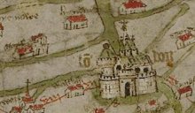
A fifteen-month research project of the earliest surviving geographically recognizable map of Great Britain, known as the Gough Map, provides some revealing insights into one of the most enigmatic cartographic pieces from the Bodleian collections. The findings are recorded on a newly-launched website www.goughmap.org.
The fifteen-month AHRC-funded [Arts and Humanities Research Council] project used an innovative approach that explores the map’s ‘linguistic geographies’, that is the writing used on the map by the scribes who created it, with the aim of offering a re-interpretation of the Gough Map’s origins, provenance, purpose and creation of which so little is known.
Although the identity of the map-maker is unknown, it is now possible to reveal that the text on the Gough Map is the work of at least two scribes: the original 14th-century scribe and a 15th-century reviser.
[Clip]
One of key outcomes of Linguistic Geographies is to make available online a searchable version of the Gough Map based upon a digital image of the map. The website features a zoomable, pan-able digital version of the Gough Map – this map is fully searchable and browse-able by place name (current and medieval), and also by geographical features. Once clicking on a chosen location, information regarding that location’s geographical appearance, etymology, appearance on earlier maps, and much, much more is revealed;
The website also includes a series of scholarly essays discussing the map; latest news about the project and a blog, among others.
Read the Complete Announcement
Direct to Gough Map
Via INFOdocket


